
The app this map came from
Weather Navigation carries the same radar and road-surface data on Apple CarPlay and Android Auto, with a weather-aware route planner, storm-cell tracking and radar that refreshes every two minutes over the US.




Scan to install Weather Navigation
Radar, DOT cameras and live pavement conditions on the 155 miles of I-40 in California — plus closures, road work and city-by-city weather across the state.
Updated Oct 8, 2026 8:33 PM PDT · Mostly dry
Lowest 84°F near Barstow, California · Highest wind 7 mph near Barstow, California
Use Weather Navigation for your next Road Trip
I-40 runs 155 miles across California.
Weather data from Oct 8, 2026 8:33 PM PDT
I-40 crosses 155 miles of California, from the Arizona line to its end in the state. That is 6% of I-40's 2,555 miles.
Inside California it meets I-15 at Barstow.
By mile marker, I-40 passes Barstow 0. It is the only city on this stretch that the mileposts name.
6 current reports along the route. The 3 most serious are listed below. Always check with the responsible state DOT before setting off.
Mainline closure. Work: Pavement Repair. Lanes closed: 1. Near Yermo, San Bernardino County.
Off Ramp closure. Work: Pavement Repair. Lanes closed: All. Near Yermo, San Bernardino County.
On Ramp closure. Work: Pavement Repair. Lanes closed: All. Near Newberry Springs, San Bernardino County.
From Barstow to Needles, with the position of each town measured along this stretch itself — counted from the Barstow end, not from a state milepost, so it will not match the numbers on the signs.
Places from the US Census Gazetteer and population estimates, both public domain; distances measured along this page's own route geometry.
The sign states the rule; R-1, R-2 and R-3 are what you hear on the radio. Caltrans does not post signs with those designations — they are shorthand it and the CHP use internally, which traffic reports then repeat. What is posted at the roadside is the requirement and the list of who is exempt, and which of the three levels is up decides whether snow tires are enough — or whether anything is. Caltrans is explicit that the sign wins: follow it, and any instruction from Caltrans or CHP staff at the checkpoint, even where it differs from a broadcast report or from a page like this one.
A snow-tread tire here carries MS, M/S, M+S or the words MUD AND SNOW on the sidewall and has at least 6/32-inch of tread — the same depth as Colorado's 3/16-inch, written the other way round. Chains means any approved traction device: link chains, cable chains, textile snow chains, hub-mounted and automatic chains all count, and Caltrans and the CHP can turn away a vehicle whose device does not meet the Vehicle Code.
Non-compliance is a citation from the California Highway Patrol, which is who enforces chain control rather than Caltrans; no fixed amount is published.
Which requirement is posted changes with the storm and with the elevation. This page does not carry it — QuickMap ↗ is the authority before you set off.
Source: Caltrans, checked September 22, 2026.
Summaries fetched Oct 8, 2026 5:01 AM PDT
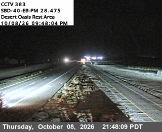
Photo from — last answered 4 hours ago, so this is the last frame we have
The same live radar and road-surface data as this map, on your phone and on Apple CarPlay or Android Auto.

Weather Navigation carries the same radar and road-surface data on Apple CarPlay and Android Auto, with a weather-aware route planner, storm-cell tracking and radar that refreshes every two minutes over the US.